Data, Data, Data! How do we Manage it?
The Florida Department of Transportation (FDOT) is responsible for over 12,000 miles of roadways. Out of that, more than 3,000 miles are implemented with some type of traffic sensor that provides a wealth of data to FDOT’s Intelligent Transportation Systems (ITS) Program in the Traffic Engineering and Operations Office along with other FDOT offices. That’s a lot of miles and a lot of data!
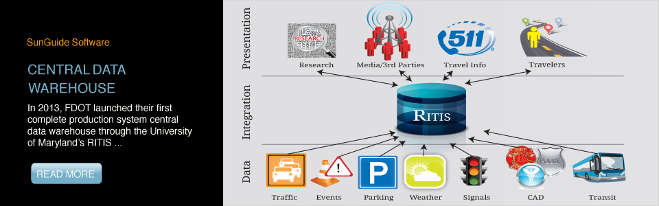
Since 2003, FDOT has been working with a prototype system for archiving data; however, in 2013 this all changed. FDOT launched their first complete production system central data warehouse through the University of Maryland’s (UMD) Center for Advanced Transportation Technology. Now both live and historical detector and event data are available from UMD’s Regional Integrated Transportation Information System (RITIS). This provides FDOT with a high reliability system which also packs horsepower through a fleet of server and storage systems. Additionally, FDOT had a few unique requirements that were met by enhancements to RITIS. New tools developed specifically for FDOT's needs now produce travel-time reliability and roadway performance measures. Along with the ITS Program, FDOT’s Planning and Safety offices as well as university and consulting firms also have access to data. RITIS also has an application programming interface for FDOT-developed tools to access and process data from within external software.
FDOT’s detector deployment along most of their limited-access facilities is predominately point detectors. Thus, as a starting point, SunGuide® software, Florida’s advanced traffic management software, was modified to send live detector data to RITIS; UMD initially integrated this data into their existing system. The next step will be for RITIS to also use probe data from FDOT’s probe detector deployments provided by the SunGuide software and probe data from Nokia’s third-party data feed. Each probe detector and the segment of roadway they cover will be shown on traffic maps. The probe detector icons will be colored to represent the status of the device and the roadway segments will be colored according to the traffic conditions being detected by the device. With just one or two clicks of the mouse, graphs and other forms of data analysis are also available.
FDOT has a contract with Nokia to provide statewide traffic speed data for limited-access facilities. This data will also be available in RITIS’s Vehicle Probe Project Suite. The Vehicle Probe Project Suite allows agencies to support operations, planning, analysis, research, and performance measures generation using probe data through web-based tools, such as a dashboard, data downloader, congestion scan, data explorer, bottleneck ranking, and user delay cost analysis, each with plenty of details and options These web-based tools allow users to download reports, visualize data on maps or in other interactive graphics, and download raw data for off-line analysis.
When issues arise, users report them to FDOT’s Central Office where they are reviewed and prioritized by FDOT and RITIS project managers. RITIS developers then address issues based on assigned priority; any needed modifications are scheduled for upcoming RITIS upgrade.
As with most systems, the users that have hands-on experience provide many of the ideas for enhancing FDOT’s RITIS experience. The RITIS development team has been very accommodating and collaborative on enhancements. They have already incorporated FDOT’s probe detectors and third-party data feeds provided by Nokia RITIS.
Future enhancements to RITIS for FDOT are discussed at the ITS Program’s Change Management Board and coordinated with RITIS through the Central Office. UMD’s forward-thinking use of innovative technology and user-centered software design for information visualization provides a great benefit to FDOT through not only data archiving, but also retrieval and analysis.