SunGuide Software: Managing Traffic Flow
In this four part series, we will highlight some of the key roles of an advanced traffic management system (ATMS) software. In this part, we will focus on how ATMS software can help transportation management centers (TMC) manage traffic flow better. In future issues, we will discuss incident management, the ability to interact with other TMCs, and performance reporting.
SunGuide® software is an ATMS software used by all regional TMCs in Florida. The Florida Department of Transportation (FDOT) and Texas Department of Transportation jointly own this software.
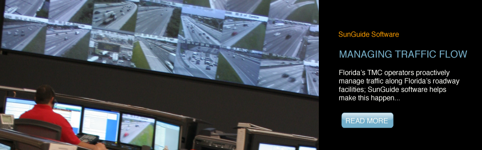
In Florida, TMCs manage traffic flow along the roadway network by scanning closed-circuit television (CCTV) cameras, detectors, and other intelligent transportation systems (ITS) devices and coordinating with law enforcement agencies and Road Ranger service patrols. These activities are fairly time consuming; if the roadway network has too few ITS devices, TMC operators have to depend heavily on law enforcement officers and Road Rangers, spending a significant portion of their time in coordination. On the other hand, if the roadway network has a significant penetration of ITS devices, then the operator could be overwhelmed with information from each of the devices. Too little or too much information harms productivity. The key is providing the information to the operator in a concise, visual manner, making it easy to process so they can efficiently balance various activities.
As software technology improves, so does the ability to present complex information in “bite-size” pieces and optimize workflow processes. It is important to use these more recent software technologies, which ensure fast data processing and are easily customized to user needs. Automating portions of traffic management and optimizing interaction with the operator is also important. We will now talk about a few areas where FDOT has automated traffic management to better support TMC operations.
Vehicle Sensors
These days, it is common practice to visually show vehicle sensor data. SunGuide software uses a color-coded map to show travel speeds, which allows operators to spot problem areas. SunGuide software also identifies when speeds along a certain roadway segment are below a configurable threshold and sends an alert to the operator informing them of the low speed. By sending an alert, SunGuide software provides the operator with information on a potential concern even if they are not viewing the map. The software also continues to track speeds to ensure that the segment has fully recovered from a previous event before sending any new alerts on that segment.
Third Party Traffic Data Providers
In Florida, we have a combination of urban, suburban, and rural areas. FDOT has deployed ITS field devices in all of our urban areas, most of our suburban, and in limited portions of our rural areas. Since some areas in Florida (mostly rural) do not have full ITS deployments, FDOT contracts with a vendor that offers real-time traffic data along these facilities. SunGuide software is integrated with this third party traffic data provider. Also, to maintain the similar look and feel that TMC operators are used to, this data is shown on the SunGuide software map as color-coded roadway segments similar to the vehicle sensor data. Color-coded roadway segments are configurable, allowing TMC operators to choose what speed range should be considered free flow, versus what speed range should be considered as a stop-and-go traffic condition. At first glance, this may not seem to be an important configuration parameter, but consider that rural areas may have a different interpretation of congested and stop-and-go conditions than urban areas where congestion is a common occurrence during morning and evening peak hours. This feature allows the customization necessary to visually present traffic conditions data in a manner that is very easy for operators to interpret over many miles of urban roadways.
Video Feed Processing
Part of the overall objective for SunGuide software is to have a fully integrated system that offers information in a consistent format independent of the technology or type of device. SunGuide software accomplishes this by integrating with a vendor product that processes CCTV camera feeds to identify if any stopped vehicle is in the camera’s field of view. SunGuide software obtains this information from the vendor product and provides alerts to the operator in the same interface as the vehicle sensor alerts. This allows the operator to maintain only one screen to view all the alerts. Manually scanning all CCTV cameras would be a monumental task for operators. This feature provides a benefit by allowing the software to scan the CCTV cameras faster than operators could and automatically identifying potential traffic flow issues. This helps identify traffic incidents sooner with less manual work from operators.
Weather Data and Third Party Weather Data Providers
FDOT has a few road weather information systems devices deployed along its limited-access facilities. SunGuide software also receives weather data for the entire state from a vendor. This data is configurable in SunGuide software so the TMC operator can choose weather events (e.g., fog, hurricane, heavy rain, tropical storm) for which they would like to receive information. SunGuide software can notify operators of approximately 21 different weather event types. Operators can use this information to prepare for upcoming severe weather conditions. The alerts appear on the same screen as the traffic incident alerts. Operators can disseminate this information to motorists and to the FL511 traveler information system as traffic events allowing motorists to plan trips around, prepare for, or just be aware of any potential weather issues that may affect their safety and mobility.
FHP CAD Data Integration
As mentioned previously, TMC operators also receive incident information from law enforcement. About two years ago, SunGuide software was modified to receive incident information from the Florida Highway Patrol’s computer-aided dispatch (CAD) system, allowing receipt of incident details as soon as they are entered or updated in the CAD system. SunGuide software provides the information as an alert on the same screen as the other alerts. This is another great traffic management tool for FDOT, especially in rural areas where FDOT has not fully deployed ITS devices.
Summary
Florida’s TMC operators proactively manage traffic along Florida’s roadway facilities; SunGuide software helps make this happen. SunGuide software integrates all ITS devices along the limited-access facilities and provides information visually or consolidates the “actionable” information for the operators from a single application. In this part of our series, we highlighted five different technologies that SunGuide software uses to automate traffic management, including monitoring vehicle sensors, third party traffic data feeds, video feeds, third party weather data feeds, and FHP’s CAD system for incident information. It is important to build business intelligence into the software using concepts that lend themselves to offering value-added services to the TMC operators. Business intelligence allows TMC operators to identify incidents quicker. As a result, operators are able to clear incidents faster and keep traffic flowing.
Stay tuned for the future parts of this series. We will explore how SunGuide software uses business intelligence in other aspects to support TMCs.